North America spreading out into nothingness
Earlier today, I was talking to a woman that I work with about ancient maps. We were joking about how odd some of them looked compared to actual pictures of the planet. I always found it interesting that, on many early maps, the detail of certain places was so precise while others were just way off. I am impressed by how accurate some of these mapmakers were with Europe and Africa in particular. Sometimes with only accounts from explorers, merchants, etc., these mapmakers would create nearly exact representations of islands, countries, and continents.
One of the more odd representations that I've seen is shown below. In it, Europe, Africa, and Asia seem to be pretty spot on. But North America is this odd blobby thing that kinda fades off the edge of the map. I figured that this was so because people didn't know much about North America at this point, but the map was made between 1749 and 1784. While much of the extent of North America was not known until Lewis and Clark (and others) returned in 1806, surely there was as much knowledge about North America as there was about Africa at the same time. I wonder why the map doesn't reflect this. Maybe I'm missing something obvious, but it seems to me that if they could (fairly) accurately reflect the size and shape of Africa, Asia, and South America, they could do it with North America as well.
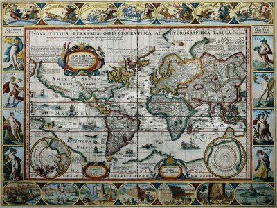
[Click on the map for a larger image]
One of the more odd representations that I've seen is shown below. In it, Europe, Africa, and Asia seem to be pretty spot on. But North America is this odd blobby thing that kinda fades off the edge of the map. I figured that this was so because people didn't know much about North America at this point, but the map was made between 1749 and 1784. While much of the extent of North America was not known until Lewis and Clark (and others) returned in 1806, surely there was as much knowledge about North America as there was about Africa at the same time. I wonder why the map doesn't reflect this. Maybe I'm missing something obvious, but it seems to me that if they could (fairly) accurately reflect the size and shape of Africa, Asia, and South America, they could do it with North America as well.
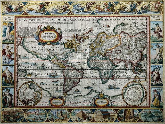
[Click on the map for a larger image]
posted by Spec at 5:22 PM
3 comments
![]()

3 Comments:
I'm just guessing here, but isn't the accuracy that you (correctly) recognize a reflection of the accuracy of the continental borders?
And furthermore, isn't it correct (??) that the exact dimensions of the West coastline wasn't as squared away as that of the Eastern coastline and the Gulf/Caribbean area?
So, wasn't it a reflection of where explorers had sailed the most and where they hadn't?
My esteemed colleague has something there. I'm noticing how undefined the northern coasts of North America and Asia are, no doubt because the cartographers hadn't gone there - or hadn't done the measurements. But they were great with the pagan deities around the edges. As the latter-day explorer Michael Franks put it, "I really like your North America / I like to feel your warm Brazil / And touch your Panama / But your Tierra del Fuegos / Are nearly always froze. Popsicle Toes..."
Thanks for the poem Sven!
I think that you are correct Burb. It just seems to me that they would be at least a little more accurate...
Post a Comment
<< Home